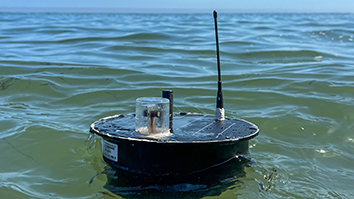
Some of SRI International’s most impactful work happens to take place in the most spectacular settings. In addition to extensive information technology, logistic, and communications support for NSF science projects in the Arctic, SRI builds and operates world-leading atmospheric research radars in some very remote places.
One of those places is Resolute, on Cornwallis Island in the Canadian Arctic. Resolute is the second farthest northern settlement in Canada. The people who run the infrastructure there say “Resolute is not the end of the world, but you can indeed see it from there.”
Home to an Inuit community of about 150 people, Resolute is one of the coldest inhabited places on the planet. The average annual temperature is a few degrees above zero (~4°F, −16°C).
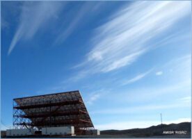
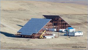
SRI has operated a research station at Resolute for more than 20 years and installed a huge atmospheric radar system designed and built by SRI engineers (a 2-MW phased array Advanced Modular Incoherent Scatter Radar, or AMISR) there a few years ago. Although the station is normally operated from Menlo Park, California over a satellite link, members of SRI’s Center for Geospace Studies spent much of July and August in Resolute finalizing the installation of a second AMISR system to be operated by our Canadian colleagues.
Six SRI staff were on the ground in Resolute, supported by many more in Menlo Park as well as contractors in Resolute, for the final push. We were lucky to find the area enjoying the best weather any of us can remember.

Resolute lies on the north shore of the fabled North West Passage and, in the clear arctic air, the team were treated to spectacular sunsets over the sea and smaller islands when returning to the hotel in the late evening. At this time of year, the days shorten rapidly as the continuous daylight of summertime midnight sun change to the months of winter darkness when the Sun doesn’t rise at all. Every day’s sunset brought a new aspect to one of the finest views of any commute.
The new radar completes a first-of-its-kind pair looking in opposite directions into both the deep polar cap and into the region where the northern lights (aurora borealis) form in response to changes in the interaction between the Sun and the Earth’s magnetic field and atmosphere.
When running at full power, the radars consume nearly three times as much electricity as the whole of the rest of the settlement, so the installation includes its own dedicated diesel generators. With only one cargo ship a year, and only one fuel tanker visit, the logistics of operating a major facility at such a remote site can be challenging.
Nevertheless, the radars give us an unprecedented view of this complex region of Geospace and will help us understand how the Earth responds to changes in its interactions with the Sun and the important effects they can have on technological systems such as GPS and radio communications.
SRI’s Center for Geospace also operates a similar radar in Alaska, another radar in Greenland, and the Arecibo Observatory (the world’s largest dish) in Puerto Rico. These facilities are all owned by the National Science Foundation and operated by SRI under a variety of cooperative support agreements. The views from all these facilities are spectacular.
The Advanced Modular Incoherent Scatter Radar project is sponsored by the National Science Foundation. Any opinions, findings and conclusions or recommendations expressed in this publication are those of the author(s) and do not necessarily reflect the views of the National Science Foundation.