• Skip to primary navigation
  • Skip to main content
SRI logo
  • About
    • Press room
    • Our history
  • Expertise
    • Advanced imaging systems
    • Artificial intelligence
    • Biomedical R&D services
    • Biomedical sciences
    • Computer vision
    • Cyber & formal methods
    • Education and learning
    • Innovation strategy and policy
    • National security
    • Ocean & space
    • Quantum
    • Robotics, sensors & devices
    • Speech & natural language
    • Video test & measurement
  • Ventures
  • NSIC
  • Careers
  • Contact
  • 日本支社
Search
Close
Press release April 22, 2019

SRI International Demonstrates Interferometric SAR with Radar Designed for CubeSat Form Factor

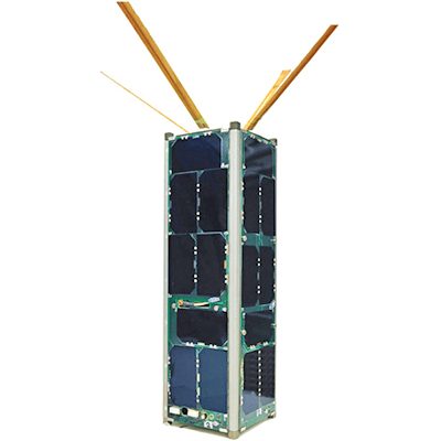
MENLO PARK, Calif.— April 22, 2019—Researchers from SRI International have successfully demonstrated new Interferometric Synthetic Aperture Radar (InSAR) capabilities with a radar developed for CubeSat-based earth science applications. Designed for the power and thermal requirements of the space environment, the low-weight, highly compact sensor has the potential to improve short-term forecasting of geologic hazards and enable more effective management of natural resources.

InSAR allows for a radar sensor to take high-precision images of an area of interest, such as a volcano or earthquake zone, and measure the differences in ground deformation across multiple data collection times. For maximum impact, InSAR measurements must be precise to the sub-centimeter level, as well as timely. Leveraging the increasing availability of CubeSats, SRI is working to provide high-precision ground deformation measurement capabilities that can be deployed in a constellation of InSAR sensors capable of daily monitoring of geologic targets.

“This is an exciting new phase to our scientific survey work we conducted over Kilauea during the volcanic eruption. Our expertise in developing systems for use in austere conditions can now be extended into space, helping geologists to better understand, characterize and measure geologic deformation of the Earth’s surface,” said Patrick Rennich, principal research engineer, Signals and Space Technology Laboratory, SRI International. “These highly precise measurements can provide scientists with key information to help improve forecasting models for natural phenomena such as volcanos, earthquakes, and landslides.”

SRI researchers designed, developed, and tested the SRI CubeSat Imaging Radar for Earth Science (SRI-CIRES) to fit within CubeSat and hobbyist-level UAV size, weight, and power constraints. During the 2019 CubeSat Developers Workshop, SRI will present the initial UAV flight test results of SRI-CIRES, showing that the prototype can meet the science objectives and performance requirements of an operational mission.
Share this
Career call to action image

Work with us

Search jobs

How can we help?

Once you hit send…

We’ll match your inquiry to the person who can best help you.

Expect a response within 48 hours.

Our work

Case studies

Publications

Timeline of innovation

Areas of expertise

Institute

Leadership

Press room

Media inquiries

Compliance

Careers

Job listings

Contact

SRI Ventures

Our locations

Headquarters

333 Ravenswood Ave
Menlo Park, CA 94025 USA

+1 (650) 859-2000

Subscribe to our newsletter


日本支社
SRI International
  • Contact us
  • Privacy Policy
  • Cookies
  • DMCA
  • Copyright © 2023 SRI International
Manage Cookie Consent
To provide the best experiences, we use technologies like cookies to store and/or access device information. Consenting to these technologies will allow us to process data such as browsing behavior or unique IDs on this site. Not consenting or withdrawing consent, may adversely affect certain features and functions.
Functional Always active
The technical storage or access is strictly necessary for the legitimate purpose of enabling the use of a specific service explicitly requested by the subscriber or user, or for the sole purpose of carrying out the transmission of a communication over an electronic communications network.
Preferences
The technical storage or access is necessary for the legitimate purpose of storing preferences that are not requested by the subscriber or user.
Statistics
The technical storage or access that is used exclusively for statistical purposes. The technical storage or access that is used exclusively for anonymous statistical purposes. Without a subpoena, voluntary compliance on the part of your Internet Service Provider, or additional records from a third party, information stored or retrieved for this purpose alone cannot usually be used to identify you.
Marketing
The technical storage or access is required to create user profiles to send advertising, or to track the user on a website or across several websites for similar marketing purposes.
Manage options Manage services Manage {vendor_count} vendors Read more about these purposes
View preferences
{title} {title} {title}