The 75 Years of Innovation series highlights the groundbreaking innovations spanning from SRI’s founding in 1946 to today. Each week, SRI will release an innovation, leading up to its 75th anniversary in November 2021.
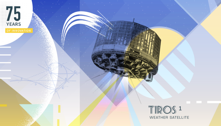
A short life but a long legacy: The story of the TIROS 1 Observation Satellite
Rain or shine, weather reporting and predicting is intrinsic to our everyday lives, affecting everything from farming to holiday travel. Being able to have long-range and accurate predictions on weather patterns has been a goal of humankind since our existence. Rather than sticking a finger in the air and seeing which way the wind is blowing, NASA and the Radio Corporation of America (RCA, now part of SRI International) designed and built a satellite to take weather images in space and send them back to Earth.
Meteorological (weather) satellites are used extensively today to observe and monitor Earth weather patterns. TIROS 1 was the first successful weather satellite to be launched. The collaboration between RCA, NASA, and other partners would create a satellite that would set a precedent for future meteorological satellites.
Here is the story of the TIROS 1 journey into space and the images it sent back to the ground.
The eyes in the sky
The TIROS, or Television InfraRed Observation Satellite program was originally launched by the U.S. government under the watch of NASA. Back in the mid-1950s, the Air Force WS-117L reconnaissance satellite competition researched the idea that a satellite could potentially carry a television camera into orbit then send images back to Earth. ARPA also began to look at the use of satellites to take images of Earth’s weather systems, eventually passing the program onto NASA. The TIROS program emerged from this original research.
The goal of the TIROS program was to demonstrate the use of television cameras, carried by a satellite, in observing the Earth’s cloud cover.
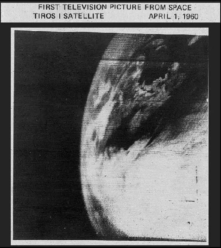
TIROS 1 was launched on April 1, 1960, from Cape Canaveral in Florida, USA. The satellite operated for a total of 78-days, during which time the first television picture was sent from space. In those 78-short days, the satellite’s video systems were able to transmit thousands of images showing the cloud-cover across the Earth. An early photograph, below, shows the structure of a large cloud system.
The success of TIROS 1 led to a continued U.S. meteorological satellite program that ran for 10 original versions of TIROS and many further iterations through to an Advanced TIROS N launched in 2009.
Satellite of collaborative love
Back in the 1950s and 1960s, Radio Corporation of America (RCA, now part of SRI International) was working on state-of-the-art television technology. The television technologies that RCA was so famous for were also used in TIROS 1.
RCA set up the ‘’Astro-Electronics Products Division ‘’ and in January 1959, the team won a NASA program to help in the design and building of TIROS, a satellite that could house television cameras to observe and take images of weather conditions.
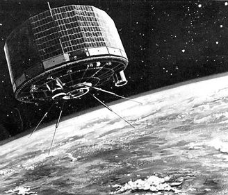
TIROS 1 was a poster child for successful collaboration across multi-disciplinary teams. The satellite was powered by 9,000 silicon solar cells. It contained two crossed-dipole 235-MHz FM telemetry antennas, used for image and data transmission.
RCA placed two shuttered television cameras (Vidicon tube type) on the 270-pound TIROS 1; one wide and one narrow angle. Each camera recorded up to 32 images, the camera pointing directly at the Earth once every satellite rotation. When infrared sensors detected the lens was vertical to the Earth, the Vidicon took a picture. The cameras were highly controllable and could be operated sequentially or alternatively. The recording, an analog signal, was stored and eventually transmitted back to earth. Unlike previous attempts, the images were of high-resolution.
A TIROS 1 legacy
TIROS-1 was a sophisticated and revolutionary weather satellite. In addition to taking images of weather systems, TIROS 1 was able to detect and count particles in cosmic radiation and study heat transfer between the tropics and polar regions.
The cloud observations made by TIROS 1 were recorded, one such note stating:
“Recognizable features of cloud systems have been and are being located accurately with respect to points on the earth’s surface. From these features, major storms have been spotted and their progress watched with interest…”
The success of TIROS 1 was immediately noted. TIROS 1 was described by the Air Weather Service (AWS) in April 1960 as “…the most significant development affecting meteorology since the introduction of weather analysis and forecasting by computers”
The “end” of TIROS 1 was on June 29th, 1960, and was according to NASA at the time, caused by a “failure of electronic equipment”. Its legacy would live on, as TIROS 1’s success allowed the creation of a long-lasting program of TIROS 1 inspired meteorological satellites.
Resources
NASA Video of TIROS-1: https://www.youtube.com/watch?v=Oe4jGbbXnvw
R.C. Hall, A History of the Military Polar Orbiting Meteorological Satellite Program, September 2001, Office of the Historian, National Reconnaissance Office: https://www.airweaassn.org/reports/prog-hist-02.pdf
NASA, TIROS Program: https://science.nasa.gov/missions/tiros/
75 Years of Innovation: CCD Broadcast Camera, The Dish, https://medium.com/dish/75-years-of-innovation-ccd-broadcast-camera-61b0920c80db
Charles W. Dickens and Charles A. Ravenstein, with John F. Fuller, ed., Air Weather Service and Meteorological Satellites, 1950–1960: http://www.airweaassn.org/reports/Pages%20from%20Air%20Weather%20Service%20and%20Meteorological%20Satellites,%201950–1960_partA.pdf